Auke Lake (Áak’w in Tlingit, literally ‘little lake’). Juneau, Alaska. Beyond the lake low black line of hills, the Coast Range mountains rise above Mendenhall Glacier.
This one day of mirrors and mountains and water remains one of my best memories of Juneau.
CLICK IMAGE Video as I explore a Fabulous Blue Ice Cave. Feel the satin of ice, strangely warm to touch.
Click image for video: This fabulous blue ice cave that I explored in 2017 has vanished. Feel the satin of ice, strangely warm to touch. Look through 1.2 meters (4 ft.) of clear ice. Mendenhall Glacier, Juneau, Alaska.
I mountain biked across frozen Mendenhall Lake in February 2017 to visit this ice cave.
Completely alone in the cave, I had time to sit quietly with the sound of flowing water, surrounded by shimmering blue walls. Eventually, I narrated this short reflection on a place that would disappear forever.
I visited the cave several more times in February, finding crystal boulders of ice that had fallen from the roof.
The cave has completely vanished as the glacier melts and retreats, melted into water that fed Mendenhall Lake and river last summer, an ephemeral creation and ghost of changing climate and rapid glacial retreat.
Over the next couple of Alaska Billy Blog posts, I’ll continue with more photos and thoughts about this cave and the Mendenhall Glacier.
For additional photos and stories, please visit me on Instagram. I post one photo and story each day.
CLICK PHOTO TO VIEW VIDEO: Nugget Falls cascades into Mendenhall Lake; Mendenhall Glacier in distance
Nugget Falls roars into Mendenhall Lake, Juneau, Alaska. Follow the creek as it flows into Mendenhall Lake (frozen), and you can see the foot of the Mendenhall Glacier in the distance.
The snowy peak prodding the blue sky is Mount Stroller White (1,570 m; 5,150 ft). The forested ridgeline in front of Stroller White that ascends to the left is one of the shoulders of Mt. McGinnis (1,289 m; 4,228 ft).
Nugget Creek arises from Nugget Glacier, flowing down a valley that separates Mount Bullard (1,288 meters; 4,225 ft.) from Heintzleman Ridge. My IG Post from 11/27/2017 shows me on cross country skis with Mount Bullard in the background.
A dam and a 198-meter (650-foot) long tunnel were constructed by the Treadwell Company during the heyday of early hardrock gold mining in Juneau. This hydroelectric facility provided electricity from 1912 to 1943, just one of a number of hydroelectric plants that put Juneau at the forefront of early industrial use of electricity, including electric locomotives.
Nugget Falls is one of the most popular tourist attractions in Juneau along with the Mendenhall Glacier. It’s also one of our favorite 30-minute hikes of exceptional beauty and the power of the waterfall.
CLICK PHOTO for video of Juneau Icefield from Helicopter
Video-Juneau Icefield viewed from Astar 119 helicopter just above Taku Inlet, probably over Norris Glacier. The helicopter pilot is our son, Rion Hanson. Although named the Juneau Icefield, it extends 140 km (87 mi) north to south and 75 km (47 mi) east to west, making it the 4th largest icefield in the Northern Hemisphere.
Era Helicopters has a dog sledding camp on the icefield for summertime tours, with access only by helicopter. I’ve flown over different parts of the icefield during the last 40 years, and it remains one of the most astoundingly beautiful places I’ve seen. At its thickest, the ice is 1,400-meters (4,590 ft.) deep!
While valley glaciers like the Mendenhall, Eagle, Herbert, and Taku Glaciers near Juneau flow down close to sea level, the vast ice field is completely invisible from saltwater and cities.
Fog rises as the Mendenhall River flows out of Mendenhall Lake. The water is clearing up now that winter is setting in. Kate Troll, Nellie the Sheltie, and I skied around the shoreline of Mendenhall Lake to the outlet where the Mendenhall River originates.
Glacial rivers change radically from summer to winter. With summer warming, the melting glacier greatly increases the river flow, making the Mendenhall River a whitewater rafting destination for tourists. Silt from the glacier turns the water an opaque gray, and rafters can hear the hiss of silt against the rafts. In winter, flow is much less, and water more clear.
Mendenhall Glacier also causes jökulhlaups (an Icelandic term), glacial outburst floods. Meltwater builds up under the glacier, trapped by ice dams. When the ice dam melts away or breaks, the water bursts out, causing the Mendenhall River rise to flood stage very quickly. These jökulhlaups have become more predictable with sensors placed under the glacier to monitor water build-up.
Mendenhall River & Mount Bullard (1,288 meters; 4,225 ft.) behind Bill Hanson. I’m standing about 6 meters (20 feet) above sea level.
Kate Troll, Nellie the Sheltie, and I skied around the shoreline of Mendenhall Lake a few days ago to the outlet where the Mendenhall River originates.
A little over a century ago, we would have been under the ice of the Mendenhall Glacier in this spot. Today, the glacier is 3.5 Km (2.2 miles) away and receding rapidly. Sometime in the next few years, it will no longer touch Mendenhall Lake, and icebergs will disappear.
Snow was beautiful, but has now given way to light rain. I’m thankful that I skied when the skiing was wonderful. Like many other places in Juneau, we treasure the beauty of our landscape—a new, magical view with nearly every kick of the skis.
We tried skiing on the lake and ran into slushy overflow beneath pristine fluffy snow. First job – scraping ice caked on our skis. Second—adjusting plan to ski the shoreline. Kate and I both have waxing skis. Mine are about 45 years old (!)—Fisher Europa 77’s—sort of like driving a steam-powered car—heavy and long, but still have camber and metal edges, so I like them fine.
Sunrise as Mt. Juneau (3,576 ft.; 1,090) m rises straight up from sea level to towers over Douglas Bridge.
The Mt. Juneau trail is a stiff climb, with option to follow the alpine ridgeline and descend using the Perseverance Trail (13-mile round trip).
Juneau & Douglas, Alaska were originally separate competing cities. Treadwell gold mine on Douglas Island, and the Alaska Juneau and Perseverance mines on the Juneau “mainland” (North American continent) were the largest hard rock gold mines in the world from the late 1880’s thru the first several decades of the 20th century.
The Douglas Bridge opened in 1980, replacing the first bridge (built in 1935. Juneau became Alaska’s state capitol in 1906. Juneau-Douglas unified into a single municipality in 1970.
Sunrise Fog-Gastineau Channel, Juneau, Alaska: CLICK PHOTO TO SEE VIDEO
Winter Sunrise: Gossamer cobwebs of mist rise from Gastineau Channel, floating south in the early morning air flow. View from the Douglas Bridge, that connects downtown Juneau to Douglas Island (see previous post for more about the bridge and cities).
The sun will rise another few degrees above the horizon, then drift west to disappear behind the Douglas Island mountains to the right by noon. A cloudless winter day, minus 5 C (23 F). Froze my fingers taking this vid.
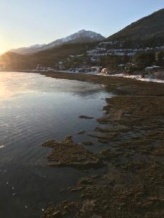
Exposed tideflats provide food for Gulls and Shorebirds, Douglas Island, Alaska
It’s low tide: along the right side of the view, Douglas Island’s exposed tideflats show as a black shadow between the sunlit water and the snow above the high tideline. Gulls and shorebirds will be feeding here among the blue mussel-kelp beds, just as they do below the Douglas Bridge.
Dark, weighty clouds in the distance nearly hide the mountains of Admiralty Island. Although the wind is light here, the thinly banded clouds between the dark bank and the blue sky look like they could be shaped by higher winds, probably coming down Taku Inlet.