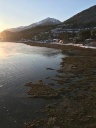
Fog rises as the Mendenhall River flows out of Mendenhall Lake. The water is clearing up now that winter is setting in. Kate Troll, Nellie the Sheltie, and I skied around the shoreline of Mendenhall Lake to the outlet where the Mendenhall River originates.
Glacial rivers change radically from summer to winter. With summer warming, the melting glacier greatly increases the river flow, making the Mendenhall River a whitewater rafting destination for tourists. Silt from the glacier turns the water an opaque gray, and rafters can hear the hiss of silt against the rafts. In winter, flow is much less, and water more clear.
Mendenhall Glacier also causes jökulhlaups (an Icelandic term), glacial outburst floods. Meltwater builds up under the glacier, trapped by ice dams. When the ice dam melts away or breaks, the water bursts out, causing the Mendenhall River rise to flood stage very quickly. These jökulhlaups have become more predictable with sensors placed under the glacier to monitor water build-up.
CLICK PHOTO to see video of Buddhist Monks Dancing at Hemis Festival, Ladakh, India
Buddhist Monks Dancing at Hemis Festival, Ladakh, India. (Click the photo at the right to watch video.)
The annual Hemis Festival is held at Hemis Gompa (Gompa = monastery), to celebrate the birth of Padmasambhava, founder of Tibetan Buddhism. Magnificent. The choreographed dancing by monks is accompanied by clashing cymbals, drums, horns, and chanting, in the courtyard of the monastery beneath the peaks of the Himalayas. These monks are dancing in heavy robes in a very hot sun around noon.
A crowd filled every inch of space-both local people and visitors. Hemis is 60 km south of the city of Leh. The summer residence of the Dalai Lama is in the immediate vicinity of Leh.
While acclimating to high altitude in preparation of our 10-day trek in the Himalayas in July 2017, we visited a number of monasteries and other special sites around Leh. We scheduled our trip so we could attend the Hemis festival.
Mendenhall River & Mount Bullard (1,288 meters; 4,225 ft.) behind Bill Hanson. I’m standing about 6 meters (20 feet) above sea level.
Kate Troll, Nellie the Sheltie, and I skied around the shoreline of Mendenhall Lake a few days ago to the outlet where the Mendenhall River originates.
A little over a century ago, we would have been under the ice of the Mendenhall Glacier in this spot. Today, the glacier is 3.5 Km (2.2 miles) away and receding rapidly. Sometime in the next few years, it will no longer touch Mendenhall Lake, and icebergs will disappear.
Snow was beautiful, but has now given way to light rain. I’m thankful that I skied when the skiing was wonderful. Like many other places in Juneau, we treasure the beauty of our landscape—a new, magical view with nearly every kick of the skis.
We tried skiing on the lake and ran into slushy overflow beneath pristine fluffy snow. First job – scraping ice caked on our skis. Second—adjusting plan to ski the shoreline. Kate and I both have waxing skis. Mine are about 45 years old (!)—Fisher Europa 77’s—sort of like driving a steam-powered car—heavy and long, but still have camber and metal edges, so I like them fine.
Our home sits on a steep hill above the saltwater, so we don’t have a back yard. I grow a few veggies in 0.9 x 2.4 m (3 x 8 ft.) box beds in our driveway.
2017 Bill Hanson with Carrots and Golden Beets from Box Beds
To make room for snowplowing, I move them back from the road. They’re around 1,000 kg (2,200 lbs.) each so it takes a bit of finagling with a floor jack, pvc pipe, a couple of heavy pry bars, maul, and heavy rope.
Moving Garden beds away from snow plowsTools for moving 1-ton garden boxes. Floor jack, heavy pry bars, maul, and heavy rope. PVC pipe-see other photos.
2017 Box Bed with Beets and Carrots
Fortunately, @katetroll is very strong. The two of us can hand push, coax, pry, and torture the beds into safety adjacent to our flower garden. With lots of travel this year, we moved beds during the first snowfall of the year.
Nelly the Sheltie – Dog of the North (northern Southeast Alaska)
Nellie the Sheltie, Dog of the North Woods (northern Southeast Alaska coastal temperate rainforest). Thanksgiving: I’m so very thankful that Nellie the Sheltie is still our effervescent companion at home and in the woods… Thanks to Lindsay and Andre, she added kayaking credentials this summer!
Kate Troll and Nellie with Wild Flag (Iris)
Last spring, we learned Nellie had an aggressive tumor in her bladder. Thought we’d lose her, but medication and diet (and no doubt love and exercise) have reduced it by half. Still zipping along, barking in circles, and giving us happiness every day at age 10.
Sunrise as Mt. Juneau (3,576 ft.; 1,090) m rises straight up from sea level to towers over Douglas Bridge.
The Mt. Juneau trail is a stiff climb, with option to follow the alpine ridgeline and descend using the Perseverance Trail (13-mile round trip).
Juneau & Douglas, Alaska were originally separate competing cities. Treadwell gold mine on Douglas Island, and the Alaska Juneau and Perseverance mines on the Juneau “mainland” (North American continent) were the largest hard rock gold mines in the world from the late 1880’s thru the first several decades of the 20th century.
The Douglas Bridge opened in 1980, replacing the first bridge (built in 1935. Juneau became Alaska’s state capitol in 1906. Juneau-Douglas unified into a single municipality in 1970.
Sunrise Fog-Gastineau Channel, Juneau, Alaska: CLICK PHOTO TO SEE VIDEO
Winter Sunrise: Gossamer cobwebs of mist rise from Gastineau Channel, floating south in the early morning air flow. View from the Douglas Bridge, that connects downtown Juneau to Douglas Island (see previous post for more about the bridge and cities).
The sun will rise another few degrees above the horizon, then drift west to disappear behind the Douglas Island mountains to the right by noon. A cloudless winter day, minus 5 C (23 F). Froze my fingers taking this vid.
Exposed tideflats provide food for Gulls and Shorebirds, Douglas Island, Alaska
It’s low tide: along the right side of the view, Douglas Island’s exposed tideflats show as a black shadow between the sunlit water and the snow above the high tideline. Gulls and shorebirds will be feeding here among the blue mussel-kelp beds, just as they do below the Douglas Bridge.
Dark, weighty clouds in the distance nearly hide the mountains of Admiralty Island. Although the wind is light here, the thinly banded clouds between the dark bank and the blue sky look like they could be shaped by higher winds, probably coming down Taku Inlet.
Sheep Creek Estuary at low tide. Gulls feeding on chum salmon eggs
Gulls feeding on salmon eggs and carcasses, Juneau, Alaska. Chum Salmon (aka “Dog Salmon”) and Pink Salmon (aka “Humpies”) spawning in Sheep Creek estuary. CLICK THE PHOTO BELOW TO SEE VIDEO: 10 seconds into video, a chum salmon with red and purple stripes thrashes into shallows. Past this chum salmon out in the channel, see the humped backs of pink salmon in spawning frenzy.
Gulls feeding on Chum Salmon eggs. CLICK IMAGE FOR VIDEO
Pinks and Chums are the only two species of salmon whose fry (newly hatched young) migrate immediately back to saltwater. They become “smolt”: their bodies and metabolism change so they can live in saltwater. The young of the other 3 species (Chinook, Coho, and Sockeye) stay in streams and lakes for 1 or more years before they go out to sea.
Once in the ocean, their life histories diverge. Pink salmon spend only 1 year feeding in saltwater, migrating back into the streams as 2-year-old adults, the smallest of the salmon at 2.2 kg (4.8 lbs.). Chum Salmon remain in the ocean for 2-4 years, so return as 3 to 5-year-olds. Their longer life of feeding and growing results in weights of 4.4 to 10.0 kg (9.7 to 22.0 lbs.)
The high protein-high fat salmon and their eggs are super-foods for predators like gulls, shorebirds, bears, and humans. As they die, the nutrients from their bodies feed aquatic and terrestrial plants and invertebrates from crab to insects in the Coastal Temperate Rainforest. These are critical habitats and migratory passages that require protection from pollutants, destruction, and blockage.
Kate Troll leans on stone chessboard in a pocket park off of Battery Park at the southern end of Manhattan Island, NY
Pocket Parks enrich a cityscape just as habitat diversity enriches a wild landscape. As Kate and I explored Manhattan for a few days, I tried to look at the cityscape through the eyes of NYC inhabitants. Impossible, of course. I won’t pretend that I know anything about cities from a city person’s perspective. In a sense I’m writing about something I know nothing about, and I’m sure I’ll prove it. I can only relate the city to my own experience.
A city is a landscape with habitats that support people, plants, and other animals. City habitats have their own energy, water, and food flow patterns; their own microclimates.
Intertidal Zonation provides diverse habitat for organisms like the Black Gumboot, barnacles & seaweed. Click image to go to detailed images and text: @bhfootloose Instagram
If you’ve followed me on Instagram (@bhfootloose), you know that I’m fascinated with habitat. Click the next two images if you want to learn more about the sea life that lives in habitats of the intertidal zone between high and low tide, or to read about the diverse plants in the small space at the base of a tree in the Southeast Alaska rainforest.
Moss and wood provide habitat for variety of plants. Click Image to read more at Instagram @bhfootloose
Walking with Kate through Battery Parkand along the esplanade at the edge of saltwater on the west shore of Manhattan Island, I began to think about how much value pocket parks add to the city. Pocket parks are tiny spaces dedicated to the enjoyment of everyone. They may look like a garden, with plants and soil, or they may display sculpture, offer benches to rest on, or perhaps chessboards for public use.
NYC Battery Urban Farm: How cool is this? Click image for more
And speaking of gardens, check out the image of the urban farm in Battery Park. I find it interesting that all of us can recognize one of these pocket parks when we see one. They contrast with the crammed buildings, the use of every square inch of space that defines a city, where land is astronomically expensive.
Diverse Wildlife Habitats: Open Muskeg with Forested Mountains in background
People live in habitats just like wild animals do. A diversity of habitats, makes a place attractive to a wider variety of people with their own needs, also similar to wildlife. It’s true, of course, that we must first fulfill our basic needs for food, water, and shelter. Beyond these, however different people have different needs. The closeness of city life may feel more secure than living and recreating in wild places. Or the reverse. People may seek solitude, a chance to be near birds and living plants, a meeting place for friends, enjoyment of art, a chance to relax… an infinite and personal list.
Like other public parks and facilities, pocket parks are for the PUBLIC, a critical concept. So much of the land, and structures of a city are privately owned. Pocket Parks belong to everyone, so they let each of us define them as a place of our own, shaped by and fulfilling our personal needs.
NYC Pocket Park: Louise Nevelson Plaza
What I heard from local residents and felt myself is that pocket parks made me happy. To walk along city streets of endless tall buildings without a gap except the streets, fully filled by stores and apartments, and then come upon a small open space with benches to sit on, perhaps with outdoor sculpture displayed, perhaps with nothing more than a shrubs and flowers (and inevitably birds and insects that I hadn’t seen for blocks), made me feel freedom, comfort, happiness.
So, my hat is off to every place that supports pocket parks. Thank you, NYC.
Can you see a cruise ship, sandbar, navigational aid, and a research vessel? Juneau, Alaska
In the photo above, I stood on the left shoreline, the edge of the North American continent. The shore and mountains of Douglas Island form the right shoreline. Gray mountains at the far end are on Admiralty Island, 12-14 miles away.
Good eyesight? Can you see a cruise ship, sandbar, navigational aid, and a research vessel in in the saltwater of Gastineau Channel? Try it and then zoom in (if using phone). When boating, I constantly search the water ahead for other vessels, navigation markers, and hazards like logs or rocks. I scan the water for any shapes, spots, or projections from the water’s surface, starting closest to me, and gradually sliding my view look down channel until I reach the horizon.
Searching the water along the left shoreline, look for rocks, sand bars, and a navigational marker on pilings. In the channel, you’ll the small research vessel operated by NOAA (National Oceanic & Atmospheric Administration) heading away from us. You’ll also see a cruise ship coming toward us that must pass between the navigation aid and Douglas Island to avoid the sand bar the extends from the left shore.
Bonaparte’s Gull & Fly fisher check each other out. Fishing alone is communion. Click to go to Instagram.